Aurora for Street Works Authorities
Symology have been developing market leading Street Works solutions for over 40 years and as a result, have become synonymous with providing the “go to” Street Works systems. Aurora is the latest of these solutions, offering comprehensive facilities for network management, providing Local Authorities with feature rich functionality for efficient management of Street Works permitting, with associated inspection and charging tools, in addition to licences and events.
Network Management
Every day, Local Authorities uphold their responsibility to monitor and effectively manage the occupancy of their network, ensuring all highway users can travel easily and safely. This network management requires reviewing incoming works and identifying their potential impact.
Aurora provides vast facilities for efficiently managing this process. Standardised dashboards categorise incoming permit applications and transactions, highlighting those which require immediate assessment, resulting in the most impactful works being reviewed first. Additional efficiencies are realised through the automated coordination checks, emphasising potential conflicts for review, and user-definable checklists ensuring consistency of permit evaluations prior to response.
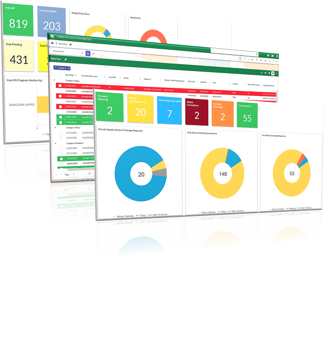
Comprehensive Dashboards
- Categorisation of permit applications by due date to prevent deeming
- Dynamic works lifecycle monitoring tools to ensure progression
- Inspection and FPN widgets for performance monitoring
A comprehensive set of dashboards process incoming works and transactions, categorising them to facilitate ease of identification of those which require attention. Assessment widgets categorise incoming permit applications from all Promoters by permit response due date, providing an instant visualisation of those which require action. Drilling into the dashboard widget category presents the due applications for individual assessment. Categorising works by the response due date minimises the risk of permits deeming and thus the commencement of potentially conflicting works with those already approved.
As permits progress through the works lifecycle, they also progress through the dashboard lifecycle and are presented on the appropriate widget for the works status. This offers a simple, effective way of ensuring works are progressing in line with the permit timetable, clearing the occupancy of the network as planned. These lifecycle monitoring facilities also assist with identification and management of Section 74 overstays and the associated processes.
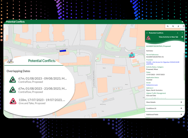
Automatic Conflict Checking
- Automatic notification of potentially conflicting works speeding up assessment process
- Differentiation between Traffic Sensitive and Non-Traffic Sensitive streets
- Clearly displayed conflicts via mapping
Aurora’s automated conflict checking reduces the amount of time it takes to review whether a works can proceed via the automated conflict checking facilities. Upon receipt of a permit application, Aurora will identify works within a defined proximity, factoring in traffic sensitivity. This streamlines the assessment process by automatically determining whether a works may conflict with an existing permit. These conflict checking facilities also flag when a permit application has been received which coincides with a Section 58 Restriction.
With the spatial display of conflicts, users can efficiently review all potential conflicts via the map, prior to determining whether to grant the permit. Conflicts are also stored against the works for auditing purposes and individual review.
User-Definable Permit Checklist
- Definition of an organisation’s checklist to ensure all assessments are completed
- Automatic assignment of checklist to each works
- Amend capability to retain most up-to-date information
For any user assessing an incoming permit application, a number of checks must be satisfied prior to granting the permit. All organisations have a standardised list of assessments in which to complete, such as ‘does the works conflict with a Section 58?’, in addition to localised assessments. Aurora accommodates user-definable assessment lists which can be modified in line with any changes to organisational procedures.
When reviewing a permit application, the associated checklist acts as a reminder to ensure all necessary criteria are met prior to submitting a permit response and any internal notes are held against the permit for future review.
Permit Reponses, when recorded, are sent back to Street Manager to ensure the Department for Transport solution is maintained as the single source of truth, and the associated assessment due list is updated.
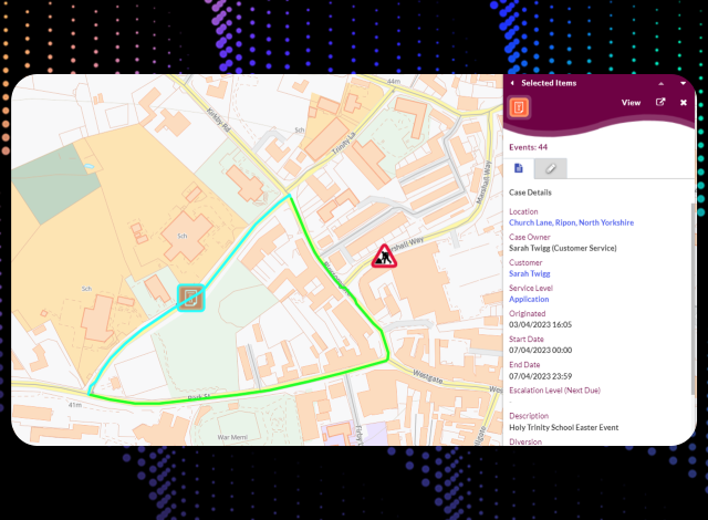
Additional Network Occupancy
Whilst permitted street works occupy the highway network, other activities including licences, events and associated diversion routes also impact the travelling public and should be not only visible but coordinated against.
Aurora simplifies the recording, management and monitoring of these additional activities alongside street works. With standard, out-of-the-box types, licences and events are spatially and textually recorded with features to accommodate multiple locations, charges and applicant or hire company details.
Associated diversion routes are easily plotted against the licence enabling coordination against both the licence itself and the additional streets on which the travelling public are directed, to minimise disruption.
Creation and distribution of all documentation, including approval and refusal documents, is accommodated in addition to emailing facilities to minimise printing.
Standardised Licences Types
- Standardised licence types available for all users
- Automation of status updates and customer communication
Standard, out-of-the-box licence types facilitate the management of a wide range of activities, including skips, scaffolding, hoarding in addition to parking bay suspensions, Section 50 licences, street cafés, temporary traffic regulation orders and events.
Spatial representation of licences with status-based symbology alongside street works provides Authorities with an instant visualisation of occupancy and the type of activity. Aurora accurately reflects the activity footprint providing multi-part plot options for point, line and polygon based spatial entities.
Whilst recording licence applications internally provides key information when managing network occupancy, it is just as important to share that externally with interested parties. The sending of applicable licence activity data to Street Manager is incorporated in Aurora, ensuring that the Department for Transport solution is kept up-to-date, providing visibility of occupancy over and above street works.
Diversion Routes
- Plotting of diversion routes for display and coordination purposes
- Routes maintained for quick selection time and time again
- Record multiple diversion routes dependent on vehicle type for accuracy
Visibility of any planned or in progress diversion routes provides key coordination information when assessing any potential occupancy. Recording these against the associated licence enables the diversion route details to be added to Licence documentation, which may be distributed to interested parties.
Following the initial recording, diversion routes are saved for selection against other licence applications, speeding up the process of creating repeated licences with the same closure and associated diversion, such as a regular event.
Licence Details and Documentation
- Charge facilities and associated Finance Codes
- Production of customer documents with manual and automated emailing facilities
In addition to a licence type and description, Aurora facilitates the recording of applicable timeframes, associated conditions for the licence, charges and finance codes all of which is available for inclusion on approval, refusal and extension documents.
The assessment piece of a licence application must be completed taking into consideration any existing proposed works or network features prior to responding. Allocation of licence applications to work queues, specific users or spatial areas is accommodated via pre-defined rule sets in order to progress to the response stage. Application response includes the production of the associated documentation either automatically upon recording of the response or manually. Furthermore, email communication, again automatically or manually generated, including required documentation is managed through Aurora for all Licences.
Tools to monitor operation in line with legislation and Codes of Practice are vital for Local Authorities
Compliance Monitoring
With works occupying a Local Authority’s network, it is important that they operate in line with legislation and Codes of Practice. The monitoring of this compliance is streamlined through extensive facilities built into Aurora.
Inspection Management and Monitoring
- Inspection sampling directly from Street Manager
- Simplified monitoring of inspection progression and performance
- Visibility of banding and category quotas
Aurora’s inspection management facilities are comprehensive, enabling receipt of sampled inspections for Street Manager, details of category quotas and tools for monitoring performance.
All prompted statutory inspections are sampled within Street Manager and downloaded to Aurora for completion via the Aurora app. Aurora’s associated app facilitates the recording of both prompted and adhoc inspections alongside the ability to view previously recorded inspections and the associated result from site, with automated triggering of a follow up inspection, where applicable. The addition of photographic evidence to inspection results assists with faster acceptance of defects leading to quicker resolution.
An out-of-the-box Inspection Dashboard includes widgets to monitor progress and performance for each of the statutory inspection categories, in addition to the number of inspections accepted and declined, including Section 81 responses. Additionally, all inspection statistics are collated in a single, easy view for visibility of all inspection progress and Promoter performance. Furthermore, due inspections are clearly displayed in due date categories to ensure that progression is made to record the correct number of inspections in each quarter.
Section 74 Overrun Management
- Overrun reporting tools for simple monitoring and progression
- Automated calculation of charges, including mitigated, using centrally maintained fee matrix
- Clear status on a per works basis for individual management
The issuing and management of Section 74 Overruns is simplified within Aurora through inspection recording, automated calculation of charges and subsequent overrun process with the Promoter.
Potential overrunning works are identified via the app dashboard for inspectors to visit, with facilities to record Site Occupancy Monitoring (SOM) inspections. With all SOM inspection results available, in addition to comments and attachments, the Aurora app streamlines the initiation of the Section 74 process.
Standard, inbuilt reporting functionality facilitates the issuing of an overrun warning, followed by subsequent management. With separate Overrun and Overrun Charges enquiries, the associated lifecycles are easily navigated, enabling reporting on all Overrun statuses.
Further simplifying the identification of an issued Overrun, a standalone Overrun section for each works displays the latest status from both the Authority and the Promoter. A direct link provides quick access to the offence itself and subsequent charges. Utilising a standardised, national fee matrix, the charge is automatically calculated based on the chosen end date and defined location.
Fixed Penalty Notice Management
- Automatic prompting of Fixed Penalty Notices in line with legislation and Code of Practice
- Management of full end-to-end lifecycle, including mobile use
- Reporting tools for performance monitoring
Works Promoters have legal responsibilities with regards to their works and the associated processes, against which Local Authorities are required to ensure compliance. In-built Fixed Penalty Notice management tools simplify the identification of noticing and compliance failures and the processes which follow.
Comprehensive validation rules are used to notify users should noticing rules in line with legislation and Codes of Practice be triggered. Whilst legislation is fixed, Aurora’s flexibility allows organisations to set which validation messages will prompt Fixed Penalty Notices for review. This automatic creation of Fixed Penalty Notices significantly reduces the time required to identify noticing failures. Following the automated prompting, individual or bulk issuing tools simplify the distribution of penalties to the appropriate Works Promoters.
Following issue, standard enquiry reporting and dashboard widgets facilitate the monitoring of Fixed Penalty Notice responses, which can also be used from a performance monitoring perspective to drive operational improvements.
Charge Controls and Administration
- Centralised Charge list for all Street Works charges
- Automatic prompting of charges
- Bulk issue and payment recording facilities
A centralised charge list within Aurora covers all Street Works charges, including nationwide permit fees, inspections, overstay and Fixed Penalty Notice. Charges are automatically established when triggered by an event, such as the recording of a permit grant or an inspection, utilising the standard charge matrix. Adhoc, manual charges are also accommodated when required.
Adjustments are facilitated through the charge screens and time-saving bulk update options, including bulk issue of charges, enable charging to be managed efficiently. Financial reporting is incorporated facilitating reports by charge type and all issued charges, with additional capability to record payment information.
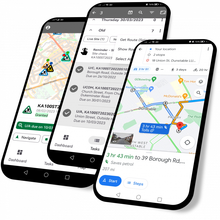
Mobile Operations
- Visibility of works details and history on site
- Recording of sampled and adhoc inspections including photographic evidence
- Initiation of Fixed Penalty Notice and Overrun Warning in addition to Comments
The Aurora app is designed to provide remote operatives with all the required information at their fingertips without the need to call or return to the office. With offline capabilities, inspectors are not restricted to the app operating only in areas with network connectivity, including the use of the map.
Works information is available, including permit status and conditions, allowing the inspector to confirm compliance with granted permit details. Access via the app eradicates a need to print or make calls to the office.
Dashboard widgets show works due to start, works due to finish, inspections due and overrunning works for works lifecycle monitoring purposes. Additionally works are displayed on the map with clear symbology depicting the works impact and status providing quick and easy identification of network occupancy and due activities.
Operational efficiencies are further achieved through the use of routing tools, both navigating via the most economical and carbon-efficient route to works, and utilising route optimising features. When selecting a number of activities to complete, mobile routing tools will navigate to each location via an optimised route, enabling an increase in productivity and also contributing to the carbon reduction effort.
Works Details On Site
- Visibility of Permit Conditions and Latest Permit Status
- Notice and Inspection History
- Non-Street Works Inspections
Visibility of works details from site ensures Inspectors have the required information to manage network occupancy. Works are displayed on the map where the symbology depicts the status. The latest permit conditions and permit status are displayed against the works. These are updated in real-time where network connectivity is available, ensuring Inspectors are working with the most up-to-date details. Where network connectivity is limited or non-existent, operations can continue offline, including use of the map. Notice and inspection information provide Inspectors with the history of a works, minimising a requirement to call the office to understand the works progress.
Other non-Street Works activity inspections, such as licences and events are facilitated via the Aurora app, ensuring monitoring and compliance of other network occupying activities.
Inspection Recording with Associated Attachments
- Visibility of due inspections with recording capability
- Facilities to record adhoc inspections
- Attachment of photographs for both external and internal publication
Aurora prompts due statutory inspections based on the Performance Based Inspections sampling process within Street Manager. These are distributed to the appropriate mobile device for completion by an Inspector. Due inspections are highlighted with defined symbology such that GPS location may be used to plan an inspection route by attending the next closest due inspection. Alternatively, a Task List enables manual route planning in addition to utilising the route optimisation facilities to navigate to the works via the most efficient route.
Adhoc inspections are also accommodated, which may consist of nationally defined inspections, or an organisation’s own defined inspections used to supplement those in the Inspections Code of Practice. Photographs taken as evidence of an inspection result are attached and issued alongside the inspection itself.
Non-Inspection Functions
- Fixed Penalty Notice Recording and Issuing
- Overrun Warning Capabilities including dashboard for identification
- Recording of Street Works Comments
In addition to the recording of inspections, other street works notifications are recorded from site for issue to Works Promoters. These include Fixed Penalty Notices, Section 74 Overrun Warnings and Comments. All can be accommodated within the Aurora App including capabilities to add photographs as evidence. Once sent from the app, Aurora is updated accordingly and any required notifications are issued to the Works Promoter.
A Progress Review option enables Inspectors to view the status of recorded actions to ensure they have been successfully issued to Aurora and thus the Works Promoters.
Web-based ESRI Mapping
Aurora’s web-based mapping offers users a familiar look and feel with standardised colour coded icons by traffic impact for ease of activity identification. Map-driven operations are facilitated through multi-select options, displaying all eligible entities to the user for selection and action.
Incorporation of Google Street View alongside Street Works and Highways licences data, simplifies the reviewing of works from a coordination and collaboration perspective, in addition to apparatus ownership.
Geographical areas are defined as spatial areas, typically representing an organisation’s operational areas or inspector patches. These spatial areas are used system wide for directing inspections and works to specific users’ mobile app in addition to tailoring views within the dashboard widgets and providing filtering options within enquiries.
Default mapping layers are provided, based on best practice, including streets from the National Street Gazetteer (NSG) and Associated Street Data (ASD), which are updated on a monthly basis using the latest published Gazetteer from GeoPlace. Inclusion of Authority local map layers, such as Highways Extent provide visibility of Authority network ownership when reviewing licence applications.
Web-based Mapping
- True web-based ESRI mapping
- Standardised symbology with colour coded activities by impact and status
- Map layers with toggle capabilities to control view
Aurora’s map centric user interface offers true web-based mapping via ESRI ArcGIS Online. Standardised, colour coded icons provide a view of network occupancy at a glance, including the traffic impact and status. This includes the display of all Promoter works, both Utility and Authority, in addition to Highway licences for a holistic view of the Authority area. Map layer toggle tools facilitate user-determined visibility of the desired map data.
Information from External Sources
- Visibility of external GIS data such as Highways Extent layers
- Monthly National Street Gazetteer (NSG) and map updates
- Google Street View
Monthly updates of the latest published National Street Gazetteer ensures consistency between Local Authority and Works Promoter systems. Greater accuracy of apparatus identification and street ownership is facilitated through the integration with Google Street View and the inclusion of local map layers within Aurora. Aurora facilitates consumption of local map layers through a regular import of static data or via WFS.
Spatial Areas
- Pre-defined spatial areas
- Cover ward areas and inspector patches
Pre-defined spatial areas cover all your operational requirements, enabling distinction of geographical areas such as wards or inspector patches with quick and easy navigation between them. Spatial areas offer a user-friendly and simple method to filter information, including the display of activities via the map and determining the geographical search parameters within the enquiries in addition to allocation of inspections to defined inspector patches.
Comprehensive Reporting Tools
Aurora’s reporting facilities provide users with all the tools needed to interpret the real life story behind their data. Easy and quick access, with multiple ways to manage their data, and thus their network, by presenting it in the most usable format for each individual and their purpose, without the need for specialised technical skills.
The dynamic, out-of-the-box dashboards offer operational, lifecycle management widgets in addition to high-level performance reporting. Widget filter options include date ranges, with drill-down capabilities to view a results grid of the records.
Dynamic enquiries offer multi-parameter searches, including the facility to plot one or multiple adhoc spatial areas in which to search. Once results have been filtered via the parameters, they are displayed in a grid, with further filtering options available alongside sorting and multi-grouping tools. User-definable data column selection and highlighting rules make pertinent information stand out to the user. Saved View facilities enable retention of the defined layout by that user for selection time and time again.
Both manual and scheduled export facilities are available in addition to pre-defined report templates, allowing reports to be sent via email or viewed via the innovative notification alert facility.
Dynamic Dashboard Widgets
- Works lifecycle monitoring tools
- Inspection performance monitoring
- Licences and Events management
Aurora’s dynamic dashboards offer visualisations of all activities and associated actions, ensuring quick identification of the status of the works occupying the network, using time-based categories, to easily monitor works through their lifecycle, ensuring prompt progression and quick identification of overdue actions. Inspection and Fixed Penalty Notice widgets provide immediate visibility of inspection and Fixed Penalty Notice statistics to monitor performance. All widgets have drill-down capabilities immediately taking the user to the detail behind the report.
Enquiry Reporting
- User-definable grid reporting
- Saveable views with scheduled export facilities
- Manual exports of data
Aurora’s vast reporting tools cover user-definable grid reporting with parameterised search options and filtering, sorting, grouping and highlighting tools for the results. Once grid views have been designed, save options are available for use time and time again. Export options are available, both manually and via a scheduled process, offering quick and easy access to your data.
Adhoc Spatial Queries
- User-defined true spatial plot search options
- Multiple spatial areas facilities
The inbuilt enquiries offer both parameterised search fields and true spatial search tools with facilities for users to plot their own polygon areas to use for their search. Increased flexibility and user control is realised through applying multiple polygons to search criteria on an adhoc basis. Further flexibility is provided via the tabular and spatial export options in addition to a map filter for the results of the enquiry.
User-selectable alerts and notifications
- Email notification defined by business triggers
- Notification alerts of pertinent information for users
Aurora enables users to select which alerts they wish to receive via email, which acts as a reminder or notification of defined events. User-configurable on screen notification alerts enable a user to be immediately alerted to an action, allowing them to react quickly.
